Severe storms, heavy rain expected on Saturday
Published 10:25 am Thursday, February 13, 2025
- The National Weather Service
A cold front is expected to move in Friday night and peak on Saturday with the threat of flooding and severe weather in Lafayette County.
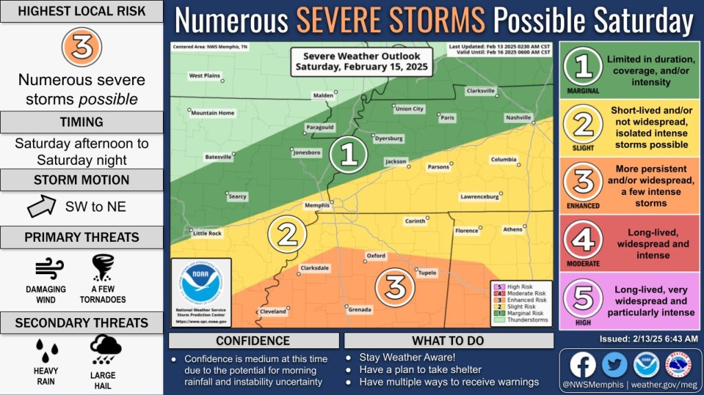
On the National Weather Service’s Severe Weather Risk scale of 1 to 5, Lafayette County is currently a 3 – or Enhanced Risk – for severe storms on Saturday.
Primary threats are damaging winds and possible tornadoes with secondary threats of heavy rain and large hail.
The storms are expected to bring in another 2 to 4 inches of rain to already saturated grounds. A flood watch is in effect from midnight. Saturday until 6 a.m. On Sunday.
Friday should be sunny with a high near 54 degrees. Around midnight, the rains will move in with thunderstorms possible in the early morning hours on Saturday.
Heavy rain will continue through Saturday with wind gusts of 25 mph possible. The high could reach about 70 degrees and then drop to a low around 35 Saturday night. Rains and storms are expected to continue throughout Saturday night and end after midnight.
Sunday will be chilly but mostly sunny after the clouds from the cold front move away. The high should be around 43 degrees with winds still gusting up to 45 mph.
Next week will be chilly and, according to the NWS, there may even be some snow coming mid-week.
The EAGLE will post any weather updates, watches and warnings as they are announced by the NWS.


-
-
-
Polls
 Loading ...